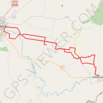
Killarney to Warwick via Tannymorel
Interactive trail map
Trail profile
- Distance: 77.0 Km
- Elevation gain: 855 m
- Maximum elevation: 668 m
- Elevation loss: 855 m
- Minimum elevation: 450 m
About this trail
Name: Killarney to Warwick via Tannymorel trail, distance, elevation, map, profile, GPS track
Coordinates: -28.33350 152.04427 -28.21850 152.29749
Other hiking, mountain biking, running and outdoor activity trails
Click on a trail to view its statistics, map and profile.
Warwick - Gatton
Australia > Queensland > Warwick
#Bike
Distance: 125.3 Km • Elevation gain: 812 m • Maximum elevation: 582 m