Thank you for supporting this site ❤️
Make a donation
Make a donation
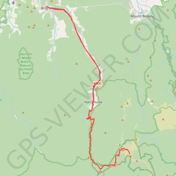
Bright - Hotham Heights
Interactive trail map
Thank you for supporting this site ❤️
Make a donation
Make a donation
Trail profile
- Distance: 110.0 Km
- Elevation gain: 3,345 m
- Maximum elevation: 1,838 m
- Elevation loss: 3,345 m
- Minimum elevation: 309 m
Thank you for supporting this site ❤️
Make a donation
Make a donation
About this trail
Name: Bright - Hotham Heights trail, distance, elevation, map, profile, GPS track
Start: 117, Gavan Street, Bright, Alpine Shire, Victoria, 3741, Australia (-36.72679 146.96119)
End: 16, Howitt Lane, Bright, Alpine Shire, Victoria, 3741, Australia (-36.72674 146.96127)
Coordinates: -37.00931 146.96119 -36.72641 147.14320
Thank you for supporting this site ❤️
Make a donation
Make a donation
Other hiking, mountain biking, running and outdoor activity trails
Click on a trail to view its statistics, map and profile.
Mount Beauty - Pyramid Hill - Bright
Australia > Victoria > Mount Beauty
#MTB
Distance: 47.8 Km • Elevation gain: 1,714 m • Maximum elevation: 1,373 m
Thank you for supporting this site ❤️
Make a donation
Make a donation
Bright Moutain Bike Park
Porepunkah Plantation. #MTB #Loop #Porepunkah
Distance: 21.4 Km • Elevation gain: 452 m • Maximum elevation: 517 m
Thank you for supporting this site ❤️
Make a donation
Make a donation