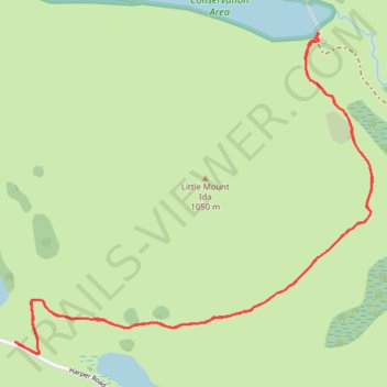
Ryton Track to Lake Ida in Glenthorne Station
- Distance: 5.7 Km
- Elevation gain: 184 m
- Maximum elevation: 713 m
- Elevation loss: 183 m
- Minimum elevation: 596 m
- Moving time: 1 h 32 m
- Moving speed: 3.7 Km/h
- Maximum speed: 4.6 Km/h
- Total time: 2 h 30 m
- Global speed: 2.3 Km/h
Interactive trail map
Trail profile
- Distance: 5.7 Km
- Elevation gain: 184 m
- Maximum elevation: 713 m
- Elevation loss: 183 m
- Minimum elevation: 596 m
- Moving time: 1 h 32 m
- Moving speed: 3.7 Km/h
- Maximum speed: 4.6 Km/h
- Total time: 2 h 30 m
- Global speed: 2.3 Km/h
About this trail
Name: Ryton Track to Lake Ida in Glenthorne Station trail, distance, elevation, map, profile, GPS track
Start: Ryton Track, Selwyn District, New Zealand (-43.24752 171.52712)
End: Ryton Track, Selwyn District, New Zealand (-43.24751 171.52723)
Coordinates: -43.24796 171.52712 -43.23601 171.54537
Other hiking, mountain biking, running and outdoor activity trails
Click on a trail to view its statistics, map and profile.