Inshriach Forest
Navigating Nature's Obstacles: A Highland Adventure at Loch Insh
- Distance: 18.1 Km
- Elevation gain: 306 m
- Maximum elevation: 343 m
- Elevation loss: 306 m
- Minimum elevation: 220 m
- Moving time: 1 h 48 m
- Moving speed: 10.0 Km/h
- Maximum speed: 29.4 Km/h
- Total time: 2 h 36 m
- Global speed: 6.9 Km/h
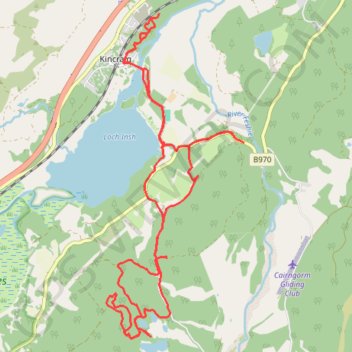
Interactive trail map
Trail profile
- Distance: 18.1 Km
- Elevation gain: 306 m
- Maximum elevation: 343 m
- Elevation loss: 306 m
- Minimum elevation: 220 m
- Moving time: 1 h 48 m
- Moving speed: 10.0 Km/h
- Maximum speed: 29.4 Km/h
- Total time: 2 h 36 m
- Global speed: 6.9 Km/h
About this trail
Name: Inshriach Forest trail, distance, elevation, map, profile, GPS track
Start: Badenoch Way, Kincraig, Highland, Scotland, PH21 1NF, United Kingdom (57.11672 -3.92060)
End: Badenoch Way, Kincraig, Highland, Scotland, PH21 1NF, United Kingdom (57.11669 -3.92061)
Coordinates: 57.09327 -3.93302 57.13299 -3.90205
Other hiking, mountain biking, running and outdoor activity trails
Click on a trail to view its statistics, map and profile.
Walk from lodge to loch and back, Loch Insh
United Kingdom > Scotland > Highland > Kincraig
Distance: 0.9 Km • Elevation gain: 23 m • Maximum elevation: 241 m