Crockett Gardens Falls via Good Water Trail in Georgetown Lake Recreational Area
Crockett Gardens Falls offer a scenic and enjoyable hike perfect for nature lovers. The path winds through shaded areas and rocky terrain, with rewarding views of Lake Georgetown from the cliffs. The highlight of the trail is the tranquil waterfall at the end, where cool spring water cascades down over lush greenery, making it a refreshing spot to relax after the hike. Whether you're dipping your feet in the water or just soaking in the views, this hike is a must for a peaceful outdoor adventure. #Hiking #Lake #Waterfall #Forest #Nature
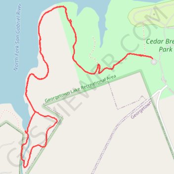
- Distance: 7.3 Km
- Elevation gain: 115 m
- Maximum elevation: 273 m
- Elevation loss: 116 m
- Minimum elevation: 241 m
- Moving time: 1 h 45 m
- Moving speed: 4.1 Km/h
- Maximum speed: 7.3 Km/h
- Total time: 1 h 46 m
- Global speed: 4.1 Km/h
Interactive trail map
Trail profile
- Distance: 7.3 Km
- Elevation gain: 115 m
- Maximum elevation: 273 m
- Elevation loss: 116 m
- Minimum elevation: 241 m
- Moving time: 1 h 45 m
- Moving speed: 4.1 Km/h
- Maximum speed: 7.3 Km/h
- Total time: 1 h 46 m
- Global speed: 4.1 Km/h
About this trail
Name: Crockett Gardens Falls via Good Water Trail in Georgetown Lake Recreational Area trail, distance, elevation, map, profile, GPS track
Coordinates: 30.66124 -97.75136 30.67448 -97.73880