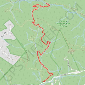
Chestnut Ridge Trail in Chesnut Ridge Heritage Preserve
The Chestnut Ridge Trail offers a moderately challenging hike through a stunning and diverse natural environment. As you traverse the trail, you'll experience a transition from newer growth forests to mature upland hardwoods, with rock outcroppings providing scenic views, especially of Hogback Mountain. Along the route, you may encounter a variety of native plants and wildlife, including the tranquil sounds of the nearby South Pacolet River, making it a rewarding excursion for nature enthusiasts. #Hiking #Forest #Nature
- Distance: 9.5 Km
- Elevation gain: 339 m
- Maximum elevation: 443 m
- Elevation loss: 339 m
- Minimum elevation: 311 m
- Moving time: 2 h 26 m
- Moving speed: 3.9 Km/h
- Maximum speed: 6.2 Km/h
- Total time: 2 h 49 m
- Global speed: 3.4 Km/h
Interactive trail map
Trail profile
- Distance: 9.5 Km
- Elevation gain: 339 m
- Maximum elevation: 443 m
- Elevation loss: 339 m
- Minimum elevation: 311 m
- Moving time: 2 h 26 m
- Moving speed: 3.9 Km/h
- Maximum speed: 6.2 Km/h
- Total time: 2 h 49 m
- Global speed: 3.4 Km/h
About this trail
Name: Chestnut Ridge Trail in Chesnut Ridge Heritage Preserve trail, distance, elevation, map, profile, GPS track
Start: Chestnut Ridge Trail, Greenville County, South Carolina, United States (35.13073 -82.28111)
End: Chestnut Ridge Trail, Greenville County, South Carolina, United States (35.13074 -82.28105)
Coordinates: 35.13072 -82.28457 35.15072 -82.27801