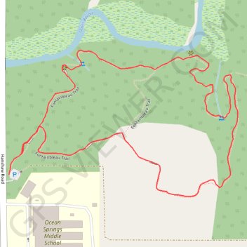
Fontainebleau Loop Trail in Mississippi Sandhill Crane National Wildlife Refuge
The Fontainebleau Loop Trail offers a delightful experience for nature enthusiasts. This well-maintained trail winds through diverse habitats, including wetlands and cypress groves, providing opportunities for wildlife observation and a chance to see unique carnivorous plants like pitcher plants and sundews. #Hiking #Loop #Forest #Nature
- Distance: 2.5 Km
- Elevation gain: 8 m
- Maximum elevation: 8 m
- Elevation loss: 9 m
- Minimum elevation: 3 m
- Moving time: 15 m 43 s
- Moving speed: 9.4 Km/h
- Maximum speed: 25.6 Km/h
- Total time: 15 m 43 s
- Global speed: 9.4 Km/h
Interactive trail map
Trail profile
- Distance: 2.5 Km
- Elevation gain: 8 m
- Maximum elevation: 8 m
- Elevation loss: 9 m
- Minimum elevation: 3 m
- Moving time: 15 m 43 s
- Moving speed: 9.4 Km/h
- Maximum speed: 25.6 Km/h
- Total time: 15 m 43 s
- Global speed: 9.4 Km/h
About this trail
Name: Fontainebleau Loop Trail in Mississippi Sandhill Crane National Wildlife Refuge trail, distance, elevation, map, profile, GPS track
Coordinates: 30.39731 -88.75724 30.40085 -88.75083