Lam Tsuen Country Park - Lung Tam Kwun Yam Temple
Hike through Lam Tsuen Country Park to Lung Tam Kwun Yam Temple. #Hiking #Mountain #Forest #Nature #Park
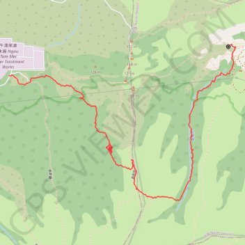
- Distance: 3.7 Km
- Elevation gain: 424 m
- Maximum elevation: 401 m
- Elevation loss: 414 m
- Minimum elevation: 31 m
- Moving time: 1 h 21 m
- Moving speed: 2.8 Km/h
- Maximum speed: 12.1 Km/h
- Total time: 6 h 11 m
- Global speed: 0.6 Km/h
Interactive trail map
Trail profile
- Distance: 3.7 Km
- Elevation gain: 424 m
- Maximum elevation: 401 m
- Elevation loss: 414 m
- Minimum elevation: 31 m
- Moving time: 1 h 21 m
- Moving speed: 2.8 Km/h
- Maximum speed: 12.1 Km/h
- Total time: 6 h 11 m
- Global speed: 0.6 Km/h
About this trail
Name: Lam Tsuen Country Park - Lung Tam Kwun Yam Temple trail, distance, elevation, map, profile, GPS track
Start: 深坑瀝, Ngau Tam Mei, Yuen Long District, New Territories, Hong Kong, China (22.47557 114.08231)
Coordinates: 22.46874 114.08231 22.47726 114.09570
Other hiking, mountain biking, running and outdoor activity trails
Click on a trail to view its statistics, map and profile.
徑口坑 營盤 泰亨坑
China > Hong Kong > Yuen Long District > Sheung Che
Hong Kong Hike
Distance: 16.7 Km • Elevation gain: 1,050 m • Maximum elevation: 487 m
Kai Kung Leng east
China > Hong Kong > Yuen Long District > Sheung Che
Distance: 3.4 Km • Elevation gain: 367 m • Maximum elevation: 396 m