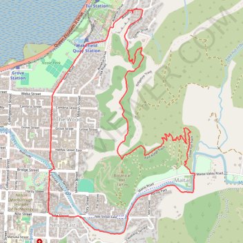
Loop around Centre of NZ, Maitai Valley, Branford Park
- Distance: 8.4 Km
- Elevation gain: 274 m
- Maximum elevation: 168 m
- Elevation loss: 274 m
- Minimum elevation: 5 m
- Moving time: 1 h 44 m
- Moving speed: 4.8 Km/h
- Maximum speed: 6.7 Km/h
- Total time: 1 h 46 m
- Global speed: 4.7 Km/h
Interactive trail map
Trail profile
- Distance: 8.4 Km
- Elevation gain: 274 m
- Maximum elevation: 168 m
- Elevation loss: 274 m
- Minimum elevation: 5 m
- Moving time: 1 h 44 m
- Moving speed: 4.8 Km/h
- Maximum speed: 6.7 Km/h
- Total time: 1 h 46 m
- Global speed: 4.7 Km/h
About this trail
Name: Loop around Centre of NZ, Maitai Valley, Branford Park trail, distance, elevation, map, profile, GPS track
Start: 18, Walters Bluff, Brooklands, Atawhai, Nelson, 7042, New Zealand (-41.25976 173.30073)
End: 18, Walters Bluff, Brooklands, Atawhai, Nelson, 7042, New Zealand (-41.25973 173.30075)
Coordinates: -41.27802 173.29148 -41.25942 173.30760
Other hiking, mountain biking, running and outdoor activity trails
Click on a trail to view its statistics, map and profile.
Nelson, Maitai Valley
New Zealand > Nelson > Nelson
Distance: 17.5 Km • Elevation gain: 468 m • Maximum elevation: 169 m