Lime Kiln Loop Trail in Rockwoods Reservation Conservation Area
The Lime Kiln Loop Trail offers hikers a scenic route with a mix of rugged terrain, steady inclines, and forested ridges. Along the way, you'll encounter historical remnants, including an old limestone kiln from the area's industrial past, as well as natural highlights like streams and small waterfalls, which add a tranquil touch. Wildlife sightings, like deer, and occasional views of nearby valleys make this trail an engaging option for those seeking a moderate challenge within Missouri’s rich natural and historical landscape. #Hiking #Loop #Forest #Nature
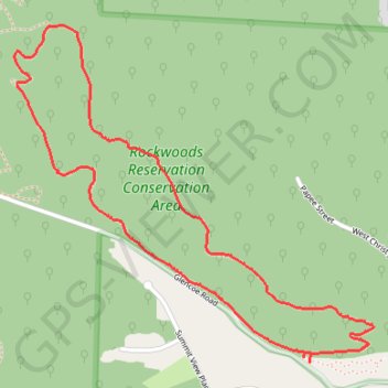
- Distance: 4.5 Km
- Elevation gain: 119 m
- Maximum elevation: 243 m
- Elevation loss: 120 m
- Minimum elevation: 158 m
- Moving time: 1 h 9 m
- Moving speed: 3.9 Km/h
- Maximum speed: 32.2 Km/h
- Total time: 1 h 17 m
- Global speed: 3.5 Km/h
Interactive trail map
Trail profile
- Distance: 4.5 Km
- Elevation gain: 119 m
- Maximum elevation: 243 m
- Elevation loss: 120 m
- Minimum elevation: 158 m
- Moving time: 1 h 9 m
- Moving speed: 3.9 Km/h
- Maximum speed: 32.2 Km/h
- Total time: 1 h 17 m
- Global speed: 3.5 Km/h
About this trail
Name: Lime Kiln Loop Trail in Rockwoods Reservation Conservation Area trail, distance, elevation, map, profile, GPS track
End: Prairie Trail, Wildwood, Saint Louis County, Missouri, 63038, United States (38.55794 -90.65174)
Coordinates: 38.55794 -90.66443 38.56927 -90.64899