Boicourt Trail via Boicourt Overlook in Theodore Roosevelt National Park
The Boicourt Trail is a brief but captivating route that offers visitors a chance to explore the dramatic Badlands landscape. The trail begins with a paved path, providing easy access to stunning views of expansive valleys and distant buttes, including the striking Buck Hill. Continuing beyond the paved section leads to a more rugged terrain, perfect for spotting wildlife such as bison and wild horses across the valley below, with the open vistas making it an ideal spot for photography, particularly at sunset. #Hiking #Overlook #Nature
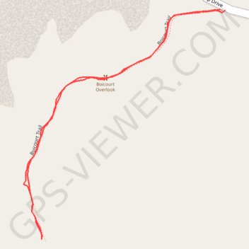
- Distance: 1.3 Km
- Elevation gain: 44 m
- Maximum elevation: 825 m
- Elevation loss: 44 m
- Minimum elevation: 795 m
- Moving time: 19 m 27 s
- Moving speed: 4.0 Km/h
- Maximum speed: 6.4 Km/h
- Total time: 20 m 46 s
- Global speed: 3.7 Km/h
Interactive trail map
Trail profile
- Distance: 1.3 Km
- Elevation gain: 44 m
- Maximum elevation: 825 m
- Elevation loss: 44 m
- Minimum elevation: 795 m
- Moving time: 19 m 27 s
- Moving speed: 4.0 Km/h
- Maximum speed: 6.4 Km/h
- Total time: 20 m 46 s
- Global speed: 3.7 Km/h
About this trail
Name: Boicourt Trail via Boicourt Overlook in Theodore Roosevelt National Park trail, distance, elevation, map, profile, GPS track
Start: Scenic Loop Drive, Scoria Point, Billings County, North Dakota, United States (46.95932 -103.40167)
End: Scenic Loop Drive, Scoria Point, Billings County, North Dakota, United States (46.95934 -103.40179)
Coordinates: 46.95563 -103.40643 46.95934 -103.40167