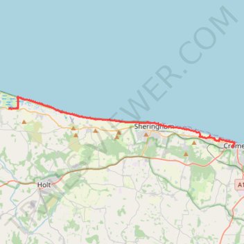
Norfolk Coast Path - Cley to Cromer
norfolk-coast-path, cley-next-the-sea, weybourne, sheringham, west-runton, east-runton, cromer
- Distance: 20.1 Km
- Elevation gain: 282 m
- Maximum elevation: 43 m
- Elevation loss: 263 m
- Minimum elevation: -1 m
- Moving time: 5 h 9 m
- Moving speed: 3.9 Km/h
- Maximum speed: 14.1 Km/h
- Total time: 6 h 9 m
- Global speed: 3.3 Km/h
Interactive trail map
Trail profile
- Distance: 20.1 Km
- Elevation gain: 282 m
- Maximum elevation: 43 m
- Elevation loss: 263 m
- Minimum elevation: -1 m
- Moving time: 5 h 9 m
- Moving speed: 3.9 Km/h
- Maximum speed: 14.1 Km/h
- Total time: 6 h 9 m
- Global speed: 3.3 Km/h
About this trail
Name: Norfolk Coast Path - Cley to Cromer trail, distance, elevation, map, profile, GPS track
End: The Croft, Cromer, North Norfolk, Norfolk, England, NR27 9EH, United Kingdom (52.93010 1.29727)
Coordinates: 52.93003 1.05509 52.96235 1.30044
Other hiking, mountain biking, running and outdoor activity trails
Click on a trail to view its statistics, map and profile.
Cley next the Sea to Binham Bike Loop
United Kingdom > England > Norfolk > North Norfolk > Cley next the Sea > Newgate
#Bike #Loop #Road #Countryside #Nature
Distance: 46.5 Km • Elevation gain: 343 m • Maximum elevation: 95 m
Walk from Wells-next-the-Sea to Cley-next-the-Sea
United Kingdom > England > Norfolk > North Norfolk > Wells-Next-the-Sea
Distance: 21.9 Km • Elevation gain: 57 m • Maximum elevation: 15 m