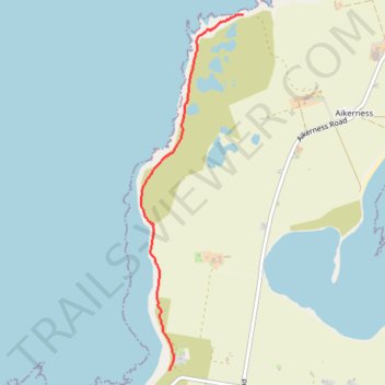
Walk on Westray
- Distance: 2.4 Km
- Elevation gain: 34 m
- Maximum elevation: 22 m
- Elevation loss: 38 m
- Minimum elevation: 3 m
- Moving time: 31 m 58 s
- Moving speed: 4.6 Km/h
- Maximum speed: 6.0 Km/h
- Total time: 31 m 58 s
- Global speed: 4.6 Km/h
Interactive trail map
Trail profile
- Distance: 2.4 Km
- Elevation gain: 34 m
- Maximum elevation: 22 m
- Elevation loss: 38 m
- Minimum elevation: 3 m
- Moving time: 31 m 58 s
- Moving speed: 4.6 Km/h
- Maximum speed: 6.0 Km/h
- Total time: 31 m 58 s
- Global speed: 4.6 Km/h
About this trail
Name: Walk on Westray trail, distance, elevation, map, profile, GPS track
Start: Quoygrew, Orkney Islands, Scotland, KW17 2DN, United Kingdom (59.35423 -2.97131)
End: Rackwick Road, Pierowall, Orkney Islands, Scotland, KW17 2DN, United Kingdom (59.33564 -2.97884)
Coordinates: 59.33564 -2.98178 59.35424 -2.97131