Silver Valley connector off Silver Knoll
- Distance: 7.3 Km
- Elevation gain: 245 m
- Maximum elevation: 177 m
- Elevation loss: 244 m
- Minimum elevation: 45 m
- Moving time: 1 h 1 m
- Moving speed: 7.1 Km/h
- Maximum speed: 15.4 Km/h
- Total time: 1 h 2 m
- Global speed: 7.0 Km/h
Interactive trail map
Trail profile
- Distance: 7.3 Km
- Elevation gain: 245 m
- Maximum elevation: 177 m
- Elevation loss: 244 m
- Minimum elevation: 45 m
- Moving time: 1 h 1 m
- Moving speed: 7.1 Km/h
- Maximum speed: 15.4 Km/h
- Total time: 1 h 2 m
- Global speed: 7.0 Km/h
About this trail
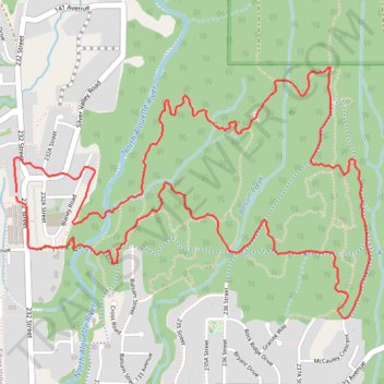
Name: Silver Valley connector off Silver Knoll trail, distance, elevation, map, profile, GPS track
Coordinates: 49.24669 -122.58090 49.25649 -122.55974
Other hiking, mountain biking, running and outdoor activity trails
Click on a trail to view its statistics, map and profile.
UBC Malcolm Knapp Forest Research - A41 trail
Canada > British Columbia > Metro Vancouver Regional District > Maple Ridge
Distance: 10.7 Km • Elevation gain: 306 m • Maximum elevation: 335 m
Maple Ridge dykes and Silver Valley
Canada > British Columbia > Metro Vancouver Regional District > Maple Ridge
Distance: 8.9 Km • Elevation gain: 73 m • Maximum elevation: 64 m