Zeopoxa Cycling
- Distance: 44.8 Km
- Elevation gain: 78 m
- Maximum elevation: 147 m
- Elevation loss: 78 m
- Minimum elevation: 110 m
- Moving time: 2 h 19 m
- Moving speed: 19.2 Km/h
- Maximum speed: 26.0 Km/h
- Total time: 2 h 26 m
- Global speed: 18.4 Km/h
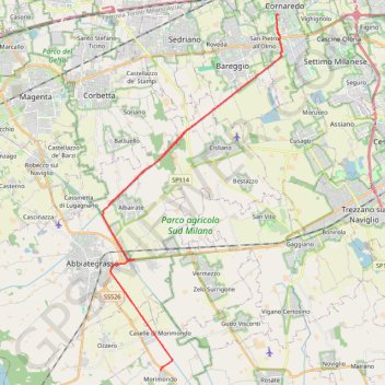
Interactive trail map
Trail profile
- Distance: 44.8 Km
- Elevation gain: 78 m
- Maximum elevation: 147 m
- Elevation loss: 78 m
- Minimum elevation: 110 m
- Moving time: 2 h 19 m
- Moving speed: 19.2 Km/h
- Maximum speed: 26.0 Km/h
- Total time: 2 h 26 m
- Global speed: 18.4 Km/h
About this trail
Name: Zeopoxa Cycling trail, distance, elevation, map, profile, GPS track
Start: Via Varese, San Pietro all'Olmo, Cornaredo, Milan, Lombardy, 20007, Italy (45.49802 9.02229)
End: Via Varese, San Pietro all'Olmo, Cornaredo, Milan, Lombardy, 20007, Italy (45.49785 9.02231)
Coordinates: 45.35577 8.92188 45.49812 9.02470