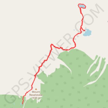
Meadows in the Sky - Eva Lake - Miller Lake
Mount Revelstoke National Park. #Hiking #Revelstoke
- Distance: 14.4 Km
- Elevation gain: 570 m
- Maximum elevation: 1,962 m
- Elevation loss: 652 m
- Minimum elevation: 1,790 m
Interactive trail map
Trail profile
- Distance: 14.4 Km
- Elevation gain: 570 m
- Maximum elevation: 1,962 m
- Elevation loss: 652 m
- Minimum elevation: 1,790 m
About this trail
Name: Meadows in the Sky - Eva Lake - Miller Lake trail, distance, elevation, map, profile, GPS track
Coordinates: 51.04073 -118.14832 51.08238 -118.10646
Other hiking, mountain biking, running and outdoor activity trails
Click on a trail to view its statistics, map and profile.