Tamanawas Falls
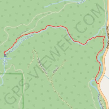
Interactive trail map
Trail profile
- Distance: 5.5 Km
- Elevation gain: 273 m
- Maximum elevation: 1,113 m
- Elevation loss: 273 m
- Minimum elevation: 925 m
About this trail
Name: Tamanawas Falls trail, distance, elevation, map, profile, GPS track
End: Mount Hood Highway, Hood River County, Oregon, United States (45.39725 -121.57154)
Coordinates: 45.39725 -121.58955 45.40498 -121.57038
Other hiking, mountain biking, running and outdoor activity trails
Click on a trail to view its statistics, map and profile.
Tamanawas Falls Trail in Mount Hood National Forest
United States > Oregon > Hood River County
The Tamanawas Falls Trail in Mount Hood National Forest offers a delightful hiking experience suitable for most skill levels. The path meanders through a lush forest, following Cold Spring Creek, cross charming wooden bridges, and culminates at the impressive Tamanawas Falls, where visitors can even venture…
Distance: 5.4 Km • Elevation gain: 238 m • Maximum elevation: 1,088 m
Northern part of the Pacific Crest Trail (PCT)
United States > Oregon > Klamath County
Hike on the Pacific Crest National Scenic Trail from Crater Lake to Canada Border through Oregon and Washington along the Sierra Nevada and Cascade mountain ranges. #Hiking #Mountain #SierraNevada #Cascade #Nature #Forest #Park #PCT
Distance: 1,198.3 Km • Elevation gain: 44,308 m • Maximum elevation: 2,307 m