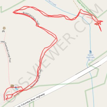
Bridal Veil Falls Trail
- Distance: 1.2 Km
- Elevation gain: 94 m
- Maximum elevation: 84 m
- Elevation loss: 90 m
- Minimum elevation: 31 m
- Moving time: 22 m 17 s
- Moving speed: 3.1 Km/h
- Maximum speed: 8.9 Km/h
- Total time: 27 m 41 s
- Global speed: 2.5 Km/h
Interactive trail map
Trail profile
- Distance: 1.2 Km
- Elevation gain: 94 m
- Maximum elevation: 84 m
- Elevation loss: 90 m
- Minimum elevation: 31 m
- Moving time: 22 m 17 s
- Moving speed: 3.1 Km/h
- Maximum speed: 8.9 Km/h
- Total time: 27 m 41 s
- Global speed: 2.5 Km/h
About this trail
Name: Bridal Veil Falls Trail trail, distance, elevation, map, profile, GPS track
Start: Bridal Veil Falls Trail, Multnomah County, Oregon, 97010, United States (45.55359 -122.18242)
End: Bridal Veil Falls Trail, Multnomah County, Oregon, 97010, United States (45.55367 -122.18217)
Coordinates: 45.55359 -122.18243 45.55529 -122.17988
Other hiking, mountain biking, running and outdoor activity trails
Click on a trail to view its statistics, map and profile.
Expedition to Sedum Ridge
United States > Oregon > Multnomah County > Portland
Distance: 214.7 Km • Elevation gain: 5,093 m • Maximum elevation: 1,169 m