Boardwalk Loop to Weston Lake Overlook
Interactive trail map
Trail profile
- Distance: 3.7 Km
- Elevation gain: 16 m
- Maximum elevation: 43 m
- Elevation loss: 16 m
- Minimum elevation: 32 m
About this trail
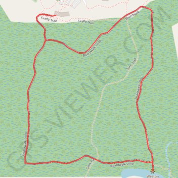
Name: Boardwalk Loop to Weston Lake Overlook trail, distance, elevation, map, profile, GPS track
Start: Boardwalk Loop, Richland County, South Carolina, United States (33.82958 -80.82376)
End: Boardwalk Loop, Richland County, South Carolina, United States (33.82958 -80.82374)
Coordinates: 33.82166 -80.82563 33.83002 -80.81781
Other hiking, mountain biking, running and outdoor activity trails
Click on a trail to view its statistics, map and profile.
Boardwalk Loop and Weston Lake Overlook in Congaree National Park
United States > South Carolina > Richland County
The Boardwalk Loop and Weston Lake Overlook offer a captivating journey through an old-growth forest, showcasing magnificent bald cypress trees and the distinctive "knees" that rise from the waterlogged soil. Along the route, visitors may observe a rich variety of wildlife, including turtles and diverse bird…
Distance: 3.9 Km • Elevation gain: 18 m • Maximum elevation: 43 m
Weston Lake Loop Trail in Congaree National Park
United States > South Carolina > Richland County
The Weston Lake Loop Trail offers a tranquil hiking experience through a lush old-growth forest. Along the route, you can expect to see towering hardwoods, such as oaks and cypress trees, alongside the tea-colored waters of Cedar Creek, which create a picturesque backdrop for nature lovers. The trail provides…
Distance: 7.8 Km • Elevation gain: 22 m • Maximum elevation: 43 m