Rudoka i Crno Ezero (Šar Planina)
- Distance: 20.5 Km
- Elevation gain: 1,720 m
- Maximum elevation: 2,649 m
- Elevation loss: 1,713 m
- Minimum elevation: 942 m
- Moving time: 7 h 55 m
- Moving speed: 2.6 Km/h
- Maximum speed: 6.5 Km/h
- Total time: 11 h 21 m
- Global speed: 1.8 Km/h
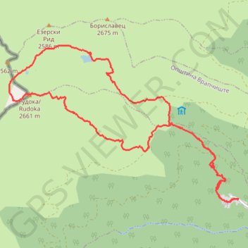
Interactive trail map
Trail profile
- Distance: 20.5 Km
- Elevation gain: 1,720 m
- Maximum elevation: 2,649 m
- Elevation loss: 1,713 m
- Minimum elevation: 942 m
- Moving time: 7 h 55 m
- Moving speed: 2.6 Km/h
- Maximum speed: 6.5 Km/h
- Total time: 11 h 21 m
- Global speed: 1.8 Km/h
About this trail
Name: Rudoka i Crno Ezero (Šar Planina) trail, distance, elevation, map, profile, GPS track
Start: Lomnica, Gjurgjevishte, Municipality of Vrapchishte, 1235, North Macedonia (41.89623 20.83590)
End: Lomnica, Gjurgjevishte, Municipality of Vrapchishte, 1235, North Macedonia (41.89635 20.83599)
Coordinates: 41.89563 20.77074 41.92890 20.83599
Other hiking, mountain biking, running and outdoor activity trails
Click on a trail to view its statistics, map and profile.
Lomnica-Crno ezero-Rudoka
North Macedonia > Gjurgjevishte > Lomnica
Distance: 21.3 Km • Elevation gain: 1,727 m • Maximum elevation: 2,649 m
Vrapchishte Piesze wędrówki
North Macedonia > Gjurgjevishte
Distance: 30.7 Km • Elevation gain: 2,124 m • Maximum elevation: 2,656 m