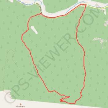
Graham and Coal Creek Loop
- Distance: 19.7 Km
- Elevation gain: 916 m
- Maximum elevation: 1,442 m
- Elevation loss: 915 m
- Minimum elevation: 696 m
- Moving time: 4 h 6 m
- Moving speed: 4.8 Km/h
- Maximum speed: 30.6 Km/h
- Total time: 7 h 5 m
- Global speed: 2.8 Km/h
Interactive trail map
Trail profile
- Distance: 19.7 Km
- Elevation gain: 916 m
- Maximum elevation: 1,442 m
- Elevation loss: 915 m
- Minimum elevation: 696 m
- Moving time: 4 h 6 m
- Moving speed: 4.8 Km/h
- Maximum speed: 30.6 Km/h
- Total time: 7 h 5 m
- Global speed: 2.8 Km/h
About this trail
Name: Graham and Coal Creek Loop trail, distance, elevation, map, profile, GPS track
Start: Coal Creek #41, Shoshone County, Idaho, United States (47.64842 -116.12075)
End: Coal Creek #41, Shoshone County, Idaho, United States (47.64834 -116.12072)
Coordinates: 47.60312 -116.13484 47.65322 -116.08678
Other hiking, mountain biking, running and outdoor activity trails
Click on a trail to view its statistics, map and profile.
Graham and Coal Creek
United States > Idaho > Shoshone County
Evening hike
Distance: 18.6 Km • Elevation gain: 886 m • Maximum elevation: 1,442 m