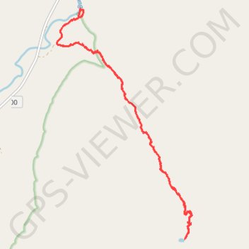
Richmond Mine Trail
- Distance: 14.4 Km
- Elevation gain: 985 m
- Maximum elevation: 1,890 m
- Elevation loss: 982 m
- Minimum elevation: 1,005 m
- Moving time: 4 h 11 m
- Moving speed: 3.4 Km/h
- Maximum speed: 17.8 Km/h
- Total time: 4 h 53 m
- Global speed: 2.9 Km/h
Interactive trail map
Trail profile
- Distance: 14.4 Km
- Elevation gain: 985 m
- Maximum elevation: 1,890 m
- Elevation loss: 982 m
- Minimum elevation: 1,005 m
- Moving time: 4 h 11 m
- Moving speed: 3.4 Km/h
- Maximum speed: 17.8 Km/h
- Total time: 4 h 53 m
- Global speed: 2.9 Km/h
About this trail
Name: Richmond Mine Trail trail, distance, elevation, map, profile, GPS track
Start: Richmond Mine Trail, Yakima County, Washington, United States (46.88127 -121.27739)
End: Richmond Mine Trail, Yakima County, Washington, United States (46.88106 -121.27746)
Coordinates: 46.84695 -121.27750 46.88698 -121.24308
Other hiking, mountain biking, running and outdoor activity trails
Click on a trail to view its statistics, map and profile.
Northern part of the Pacific Crest Trail (PCT)
United States > Oregon > Klamath County
Hike on the Pacific Crest National Scenic Trail from Crater Lake to Canada Border through Oregon and Washington along the Sierra Nevada and Cascade mountain ranges. #Hiking #Mountain #SierraNevada #Cascade #Nature #Forest #Park #PCT
Distance: 1,198.3 Km • Elevation gain: 44,308 m • Maximum elevation: 2,307 m