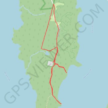
Paths on Mason Point Promontory
- Distance: 6.3 Km
- Elevation gain: 39 m
- Maximum elevation: 86 m
- Elevation loss: 38 m
- Minimum elevation: 69 m
- Moving time: 1 h 30 m
- Moving speed: 4.2 Km/h
- Maximum speed: 6.7 Km/h
- Total time: 1 h 56 m
- Global speed: 3.3 Km/h
Interactive trail map
Trail profile
- Distance: 6.3 Km
- Elevation gain: 39 m
- Maximum elevation: 86 m
- Elevation loss: 38 m
- Minimum elevation: 69 m
- Moving time: 1 h 30 m
- Moving speed: 4.2 Km/h
- Maximum speed: 6.7 Km/h
- Total time: 1 h 56 m
- Global speed: 3.3 Km/h
About this trail
Name: Paths on Mason Point Promontory trail, distance, elevation, map, profile, GPS track
Start: Transis Camp Road, Chatham County, North Carolina, United States (35.84127 -78.98724)
End: 2798, Transis Camp Road, Chatham County, North Carolina, 27713, United States (35.84126 -78.98731)
Coordinates: 35.82047 -78.99038 35.84127 -78.98384