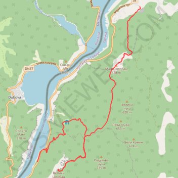
Miroč - Đerdap: Mali i Veliki Štrbac
- Distance: 17.6 Km
- Elevation gain: 766 m
- Maximum elevation: 749 m
- Elevation loss: 955 m
- Minimum elevation: 82 m
- Moving time: 4 h 44 m
- Moving speed: 3.7 Km/h
- Maximum speed: 12.3 Km/h
- Total time: 6 h 56 m
- Global speed: 2.5 Km/h
Interactive trail map
Trail profile
- Distance: 17.6 Km
- Elevation gain: 766 m
- Maximum elevation: 749 m
- Elevation loss: 955 m
- Minimum elevation: 82 m
- Moving time: 4 h 44 m
- Moving speed: 3.7 Km/h
- Maximum speed: 12.3 Km/h
- Total time: 6 h 56 m
- Global speed: 2.5 Km/h
About this trail
Name: Miroč - Đerdap: Mali i Veliki Štrbac trail, distance, elevation, map, profile, GPS track
Coordinates: 44.59169 22.26797 44.65431 22.32312
Other hiking, mountain biking, running and outdoor activity trails
Click on a trail to view its statistics, map and profile.
Miroč - Đerdap: Mali Prilaz - Veliki Štrbac - Ploča
Serbia > Central Serbia > Bor Administrative District > Majdanpek Municipality > Golubinje
Distance: 15.8 Km • Elevation gain: 920 m • Maximum elevation: 749 m