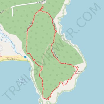
Great Head Loop Trail
- Distance: 2.5 Km
- Elevation gain: 71 m
- Maximum elevation: 39 m
- Elevation loss: 73 m
- Minimum elevation: 6 m
- Moving time: 51 m 59 s
- Moving speed: 2.9 Km/h
- Maximum speed: 9.1 Km/h
- Total time: 1 h 8 m
- Global speed: 2.2 Km/h
Interactive trail map
Trail profile
- Distance: 2.5 Km
- Elevation gain: 71 m
- Maximum elevation: 39 m
- Elevation loss: 73 m
- Minimum elevation: 6 m
- Moving time: 51 m 59 s
- Moving speed: 2.9 Km/h
- Maximum speed: 9.1 Km/h
- Total time: 1 h 8 m
- Global speed: 2.2 Km/h
About this trail
Name: Great Head Loop Trail trail, distance, elevation, map, profile, GPS track
Start: Great Head Trail, Bar Harbor, Hancock County, Maine, United States (44.33355 -68.17860)
End: Schooner Head Road, Bar Harbor, Hancock County, Maine, United States (44.33382 -68.17870)
Coordinates: 44.32570 -68.18058 44.33382 -68.17461
Other hiking, mountain biking, running and outdoor activity trails
Click on a trail to view its statistics, map and profile.
Great Head Loop Trail in Acadia National Park
United States > Maine > Hancock County > Bar Harbor
The Great Head Loop Trail offers a scenic and moderately challenging hike. As the trail winds through a mix of forest and exposed cliffs, you'll enjoy panoramic ocean views, including sights of Sand Beach, The Beehive, and Thunder Hole. The loop also features some historical interest with remnants of an old…
Distance: 2.6 Km • Elevation gain: 72 m • Maximum elevation: 40 m
Great Head Loop Trail in Acadia National Park
United States > Maine > Hancock County > Bar Harbor
The Great Head Loop Trail in Acadia National Park offers a memorable coastal hike with sweeping views of the rugged Maine shoreline. Along the way, hikers are treated to panoramic vistas of Sand Beach, Gorham Mountain, and the Beehive, as well as glimpses of Thunder Hole across the bay. The trail combines…
Distance: 2.5 Km • Elevation gain: 62 m • Maximum elevation: 39 m