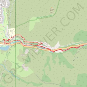
Logan Canyon Loop
Loop hike along Logan River from Ray Hugie Hydro Park via River Trail, Highline Trail and Bonneville Shoreline Trail. #Hiking #Loop #Nature #River #Canyon #Mountain #Forest #Park
- Distance: 5.0 Km
- Elevation gain: 148 m
- Maximum elevation: 1,499 m
- Elevation loss: 144 m
- Minimum elevation: 1,430 m
- Moving time: 58 m 59 s
- Moving speed: 5.1 Km/h
- Maximum speed: 7.3 Km/h
- Total time: 1 h 2 m
- Global speed: 4.8 Km/h
Interactive trail map
Trail profile
- Distance: 5.0 Km
- Elevation gain: 148 m
- Maximum elevation: 1,499 m
- Elevation loss: 144 m
- Minimum elevation: 1,430 m
- Moving time: 58 m 59 s
- Moving speed: 5.1 Km/h
- Maximum speed: 7.3 Km/h
- Total time: 1 h 2 m
- Global speed: 4.8 Km/h
About this trail
Name: Logan Canyon Loop trail, distance, elevation, map, profile, GPS track
Start: US 89, Hillcrest Neighborhood, Logan, Cache County, Utah, 84322, United States (41.74372 -111.78578)
Coordinates: 41.74121 -111.78853 41.74514 -111.76416
Other hiking, mountain biking, running and outdoor activity trails
Click on a trail to view its statistics, map and profile.
Highline Trail and Logan Canyon Gateway Trail loop
United States > Utah > Cache County > Logan
Distance: 5.8 Km • Elevation gain: 200 m • Maximum elevation: 1,540 m
Logan River Trail
United States > Utah > Cache County
Distance: 9.2 Km • Elevation gain: 150 m • Maximum elevation: 1,549 m
Bonneville Shoreline Trail
United States > Utah > Cache County > Logan
cycling, mtb
Distance: 9.3 Km • Elevation gain: 199 m • Maximum elevation: 1,554 m
2025-05-21_08-53_Wed
United States > Utah > Cache County > Logan
Canal Road and Canyon Road Loop Walk
Distance: 4.5 Km • Elevation gain: 78 m • Maximum elevation: 1,468 m