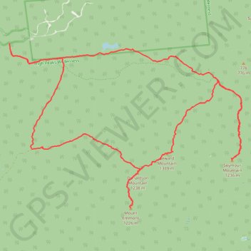
Seward Mountain, Donaldson Mountain, Seymour Mountain and Mount Emmons Loop
Loop hike to Seward Mountain via Blueberry Trail, Ward Brook Truck Trail, Seymour Trail, Seward Mountain Trail, Seward Range Trail and Calkins Brook Trail in the High Peaks Wilderness and the Adirondack Park. #Hiking #Loop #Mountain #Forest #Nature #Wilderness #Park
- Distance: 32.9 Km
- Elevation gain: 1,706 m
- Maximum elevation: 1,318 m
- Elevation loss: 1,719 m
- Minimum elevation: 533 m
- Moving time: 11 h 37 m
- Moving speed: 2.8 Km/h
- Maximum speed: 6.1 Km/h
- Total time: 12 h 39 m
- Global speed: 2.6 Km/h
Interactive trail map
Trail profile
- Distance: 32.9 Km
- Elevation gain: 1,706 m
- Maximum elevation: 1,318 m
- Elevation loss: 1,719 m
- Minimum elevation: 533 m
- Moving time: 11 h 37 m
- Moving speed: 2.8 Km/h
- Maximum speed: 6.1 Km/h
- Total time: 12 h 39 m
- Global speed: 2.6 Km/h
About this trail
Name: Seward Mountain, Donaldson Mountain, Seymour Mountain and Mount Emmons Loop trail, distance, elevation, map, profile, GPS track
Start: Blueberry Trail, Town of Harrietstown, Franklin County, New York, United States (44.18957 -74.26284)
Coordinates: 44.14389 -74.26360 44.19188 -74.16871
Other hiking, mountain biking, running and outdoor activity trails
Click on a trail to view its statistics, map and profile.