Thank you for supporting this site ❤️
Make a donation
Make a donation
2026_06_03T19_58_29Z
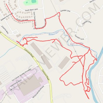
- Distance: 5.4 Km
- Elevation gain: 57 m
- Maximum elevation: 31 m
- Elevation loss: 61 m
- Minimum elevation: 7 m
- Moving time: 1 h 20 m
- Moving speed: 4.1 Km/h
- Maximum speed: 24.9 Km/h
- Total time: 1 h 26 m
- Global speed: 3.8 Km/h
Interactive trail map
Thank you for supporting this site ❤️
Make a donation
Make a donation
Trail profile
- Distance: 5.4 Km
- Elevation gain: 57 m
- Maximum elevation: 31 m
- Elevation loss: 61 m
- Minimum elevation: 7 m
- Moving time: 1 h 20 m
- Moving speed: 4.1 Km/h
- Maximum speed: 24.9 Km/h
- Total time: 1 h 26 m
- Global speed: 3.8 Km/h
Thank you for supporting this site ❤️
Make a donation
Make a donation
About this trail
Name: 2026_06_03T19_58_29Z trail, distance, elevation, map, profile, GPS track
Coordinates: 39.85129 -75.40708 39.85981 -75.39654
Thank you for supporting this site ❤️
Make a donation
Make a donation