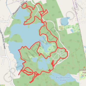
Massasoit State Park Loop
- Distance: 16.1 Km
- Elevation gain: 137 m
- Maximum elevation: 36 m
- Elevation loss: 135 m
- Minimum elevation: 5 m
- Moving time: 1 h 53 m
- Moving speed: 8.5 Km/h
- Maximum speed: 29.7 Km/h
- Total time: 2 h 7 m
- Global speed: 7.6 Km/h
Interactive trail map
Trail profile
- Distance: 16.1 Km
- Elevation gain: 137 m
- Maximum elevation: 36 m
- Elevation loss: 135 m
- Minimum elevation: 5 m
- Moving time: 1 h 53 m
- Moving speed: 8.5 Km/h
- Maximum speed: 29.7 Km/h
- Total time: 2 h 7 m
- Global speed: 7.6 Km/h
About this trail
Name: Massasoit State Park Loop trail, distance, elevation, map, profile, GPS track
Start: Park Road, Taunton, Bristol County, Massachusetts, 02349, United States (41.88057 -70.99125)
End: Park Road, Taunton, Bristol County, Massachusetts, 02349, United States (41.88136 -70.99206)
Coordinates: 41.86266 -70.99944 41.88353 -70.98195
Other hiking, mountain biking, running and outdoor activity trails
Click on a trail to view its statistics, map and profile.
Massasoit State Park
United States > Massachusetts > Bristol County > Taunton
Distance: 14.0 Km • Elevation gain: 82 m • Maximum elevation: 30 m