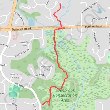
Edenbrook Conservation Area
- Distance: 3.7 Km
- Elevation gain: 22 m
- Maximum elevation: 271 m
- Elevation loss: 22 m
- Minimum elevation: 262 m
- Moving time: 57 m 14 s
- Moving speed: 3.9 Km/h
- Maximum speed: 10.8 Km/h
- Total time: 1 h 3 m
- Global speed: 3.5 Km/h
Interactive trail map
Trail profile
- Distance: 3.7 Km
- Elevation gain: 22 m
- Maximum elevation: 271 m
- Elevation loss: 22 m
- Minimum elevation: 262 m
- Moving time: 57 m 14 s
- Moving speed: 3.9 Km/h
- Maximum speed: 10.8 Km/h
- Total time: 1 h 3 m
- Global speed: 3.5 Km/h
About this trail
Name: Edenbrook Conservation Area trail, distance, elevation, map, profile, GPS track
Coordinates: 44.88305 -93.51096 44.89427 -93.50683
Other hiking, mountain biking, running and outdoor activity trails
Click on a trail to view its statistics, map and profile.
GoMap__2024_11_29__15_09_20
United States > Minnesota > Hennepin County > Eden Prairie
Distance: 3.5 Km • Elevation gain: 22 m • Maximum elevation: 271 m