Barker Dam Loop Trail in Joshua Tree National Park
The Barker Dam Loop Trail in Joshua Tree National Park offers a captivating journey through diverse desert landscapes, including striking rock formations and iconic Joshua trees. Along the trail, visitors can explore the historic Barker Dam, constructed by early cattlemen in 1900 and later enhanced by rancher William F. Keys, which now serves as a vital water source for local wildlife. Additionally, the route features ancient Native American petroglyphs, providing a glimpse into the region's rich cultural heritage. #Hiking #Desert #Rock #Nature #Loop
- Distance: 2.1 Km
- Elevation gain: 30 m
- Maximum elevation: 1,314 m
- Elevation loss: 30 m
- Minimum elevation: 1,296 m
- Moving time: 38 m 7 s
- Moving speed: 3.3 Km/h
- Maximum speed: 5.5 Km/h
- Total time: 41 m 13 s
- Global speed: 3.0 Km/h
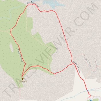
Interactive trail map
Trail profile
- Distance: 2.1 Km
- Elevation gain: 30 m
- Maximum elevation: 1,314 m
- Elevation loss: 30 m
- Minimum elevation: 1,296 m
- Moving time: 38 m 7 s
- Moving speed: 3.3 Km/h
- Maximum speed: 5.5 Km/h
- Total time: 41 m 13 s
- Global speed: 3.0 Km/h
About this trail
Name: Barker Dam Loop Trail in Joshua Tree National Park trail, distance, elevation, map, profile, GPS track
Start: Barker Dam Loop, Riverside County, California, United States (34.02528 -116.14218)
End: Wall Street Mill Trail, Riverside County, California, United States (34.02512 -116.14218)
Coordinates: 34.02512 -116.14781 34.03070 -116.14207
Other hiking, mountain biking, running and outdoor activity trails
Click on a trail to view its statistics, map and profile.