Some of the lesser know routes up the Wrekin
Wrekin alternative - Shropshire Hills National Landscape
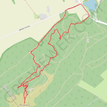
- Distance: 5.1 Km
- Elevation gain: 302 m
- Maximum elevation: 402 m
- Elevation loss: 302 m
- Minimum elevation: 150 m
- Moving time: 1 h 27 m
- Moving speed: 3.5 Km/h
- Maximum speed: 10.4 Km/h
- Total time: 1 h 40 m
- Global speed: 3.1 Km/h
Interactive trail map
Trail profile
- Distance: 5.1 Km
- Elevation gain: 302 m
- Maximum elevation: 402 m
- Elevation loss: 302 m
- Minimum elevation: 150 m
- Moving time: 1 h 27 m
- Moving speed: 3.5 Km/h
- Maximum speed: 10.4 Km/h
- Total time: 1 h 40 m
- Global speed: 3.1 Km/h
About this trail
Name: Some of the lesser know routes up the Wrekin trail, distance, elevation, map, profile, GPS track
Coordinates: 52.66928 -2.55293 52.68184 -2.53778