Iron Mountain Loop
Loop hike to Iron Mountain via Iron Mountain Peak Trail and Ellie Lane Trail. #Hiking #Loop #Mountain #Nature #Forest #Lake
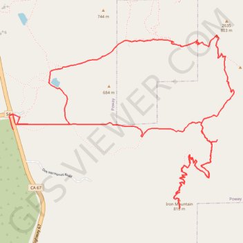
- Distance: 12.6 Km
- Elevation gain: 522 m
- Maximum elevation: 804 m
- Elevation loss: 525 m
- Minimum elevation: 487 m
- Moving time: 2 h 52 m
- Moving speed: 4.4 Km/h
- Maximum speed: 9.2 Km/h
- Total time: 3 h 24 m
- Global speed: 3.7 Km/h
Interactive trail map
Trail profile
- Distance: 12.6 Km
- Elevation gain: 522 m
- Maximum elevation: 804 m
- Elevation loss: 525 m
- Minimum elevation: 487 m
- Moving time: 2 h 52 m
- Moving speed: 4.4 Km/h
- Maximum speed: 9.2 Km/h
- Total time: 3 h 24 m
- Global speed: 3.7 Km/h
About this trail
Name: Iron Mountain Loop trail, distance, elevation, map, profile, GPS track
Start: Poway Road, Poway, San Diego County, California, United States (32.97835 -116.97352)
End: 14860, Highway 67, Poway, San Diego County, California, 92064, United States (32.97704 -116.97315)
Coordinates: 32.96997 -116.97357 32.98558 -116.94953
Other hiking, mountain biking, running and outdoor activity trails
Click on a trail to view its statistics, map and profile.
Iron Mountain
United States > California > San Diego County > Poway
From Poway Road Park and Ride, the route follows Iron Mountain Peak Trail through a short shaded start, then across open chaparral, granite outcrops, rolling foothills, and increasingly exposed slopes toward the summit of Iron Mountain. After passing the Iron Mountain Junction and the slopes around Little Iron…
Distance: 8.3 Km • Elevation gain: 343 m • Maximum elevation: 804 m
Iron Mountain Peak Trail
United States > California > San Diego County > Poway
Iron Mountain Peak Trail offers a rewarding hike with a mix of scenic landscapes and challenging ascents. The route is particularly notable for its panoramic views, including sweeping vistas of surrounding mountains like Cuyamaca Peak and El Cajon Mountain, as well as distant sights of San Diego and the ocean.…
Distance: 9.0 Km • Elevation gain: 361 m • Maximum elevation: 803 m