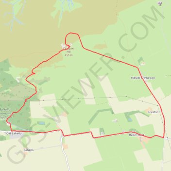
Craigowl Hill Loop
Loop run / hike from Balkello Community Woodland to Craigowl Hill. #Running #Hiking #Loop #Nature #Forest #Countryside
- Distance: 9.3 Km
- Elevation gain: 310 m
- Maximum elevation: 451 m
- Elevation loss: 310 m
- Minimum elevation: 153 m
- Moving time: 1 h 2 m
- Moving speed: 8.9 Km/h
- Maximum speed: 28.0 Km/h
- Total time: 1 h 19 m
- Global speed: 7.0 Km/h
Interactive trail map
Trail profile
- Distance: 9.3 Km
- Elevation gain: 310 m
- Maximum elevation: 451 m
- Elevation loss: 310 m
- Minimum elevation: 153 m
- Moving time: 1 h 2 m
- Moving speed: 8.9 Km/h
- Maximum speed: 28.0 Km/h
- Total time: 1 h 19 m
- Global speed: 7.0 Km/h
About this trail
Name: Craigowl Hill Loop trail, distance, elevation, map, profile, GPS track
Coordinates: 56.53164 -3.03471 56.54998 -2.98456
Other hiking, mountain biking, running and outdoor activity trails
Click on a trail to view its statistics, map and profile.
Balkello Community Woodland Loop Walk
United Kingdom > Scotland > Angus > Kirkton of Auchterhouse > Newtown of Pitpointie
Distance: 3.2 Km • Elevation gain: 95 m • Maximum elevation: 294 m