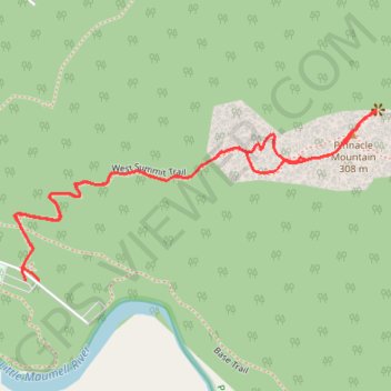
Pinnacle Mountain via West Summit Trail in Pinnacle Mountain State Park
The West Summit Trail to Pinnacle Mountain offers a moderately challenging climb with rocky sections and steep inclines. Starting in a wooded area, the trail quickly ascends to open rock scrambles, providing expansive views of the Arkansas River, Lake Maumelle, and downtown Little Rock near the summit. Though steep and requiring some handholds, the panoramic vistas at the top reward hikers with a sweeping, scenic overview of the surrounding landscape. #Hiking #Mountain #Forest #Nature
- Distance: 2.3 Km
- Elevation gain: 210 m
- Maximum elevation: 290 m
- Elevation loss: 210 m
- Minimum elevation: 86 m
- Moving time: 44 m 52 s
- Moving speed: 3.1 Km/h
- Maximum speed: 7.7 Km/h
- Total time: 1 h 28 m
- Global speed: 1.6 Km/h
Interactive trail map
Trail profile
- Distance: 2.3 Km
- Elevation gain: 210 m
- Maximum elevation: 290 m
- Elevation loss: 210 m
- Minimum elevation: 86 m
- Moving time: 44 m 52 s
- Moving speed: 3.1 Km/h
- Maximum speed: 7.7 Km/h
- Total time: 1 h 28 m
- Global speed: 1.6 Km/h
About this trail
Name: Pinnacle Mountain via West Summit Trail in Pinnacle Mountain State Park trail, distance, elevation, map, profile, GPS track
Start: West Summit Trail, Pulaski County, Arkansas, United States (34.83910 -92.49273)
End: West Summit Trail, Pulaski County, Arkansas, United States (34.83911 -92.49304)
Coordinates: 34.83910 -92.49327 34.84215 -92.48543