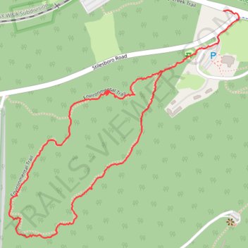
The Kennesaw Mountain National Battlefield Park Environmental Loop
- Distance: 2.6 Km
- Elevation gain: 43 m
- Maximum elevation: 387 m
- Elevation loss: 51 m
- Minimum elevation: 346 m
- Moving time: 52 m 15 s
- Moving speed: 3.0 Km/h
- Maximum speed: 9.6 Km/h
- Total time: 1 h 14 m
- Global speed: 2.1 Km/h
Interactive trail map
Trail profile
- Distance: 2.6 Km
- Elevation gain: 43 m
- Maximum elevation: 387 m
- Elevation loss: 51 m
- Minimum elevation: 346 m
- Moving time: 52 m 15 s
- Moving speed: 3.0 Km/h
- Maximum speed: 9.6 Km/h
- Total time: 1 h 14 m
- Global speed: 2.1 Km/h
About this trail
Name: The Kennesaw Mountain National Battlefield Park Environmental Loop trail, distance, elevation, map, profile, GPS track
Start: Environmental Trail, Cobb County, Georgia, 30090, United States (33.98269 -84.58047)
End: 1379, Noonday Creek Trail, Cobb County, Georgia, 30064, United States (33.98465 -84.57811)
Coordinates: 33.97737 -84.58639 33.98468 -84.57751
Other hiking, mountain biking, running and outdoor activity trails
Click on a trail to view its statistics, map and profile.
More bike ride on the Silver Comet Trail (and some other side quests)
United States > Georgia > Polk County
Distance: 76.9 Km • Elevation gain: 854 m • Maximum elevation: 350 m
Bike ride down the Silver Comet Trail (and some side quests)
United States > Georgia > Cobb County > Smyrna
Distance: 132.2 Km • Elevation gain: 1,304 m • Maximum elevation: 351 m