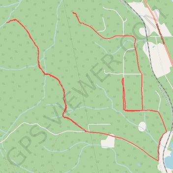
Track 20240827-154422
- Distance: 16.4 Km
- Elevation gain: 319 m
- Maximum elevation: 605 m
- Elevation loss: 287 m
- Minimum elevation: 505 m
- Moving time: 1 h 43 m
- Moving speed: 9.5 Km/h
- Maximum speed: 75.4 Km/h
- Total time: 2 h 42 m
- Global speed: 6.1 Km/h
Interactive trail map
Trail profile
- Distance: 16.4 Km
- Elevation gain: 319 m
- Maximum elevation: 605 m
- Elevation loss: 287 m
- Minimum elevation: 505 m
- Moving time: 1 h 43 m
- Moving speed: 9.5 Km/h
- Maximum speed: 75.4 Km/h
- Total time: 2 h 42 m
- Global speed: 6.1 Km/h
About this trail
Name: Track 20240827-154422 trail, distance, elevation, map, profile, GPS track
Coordinates: 54.82262 -127.27107 54.85132 -127.21735
Other hiking, mountain biking, running and outdoor activity trails
Click on a trail to view its statistics, map and profile.
Trail near Twin Falls, Smithers BC
Canada > British Columbia > Regional District of Bulkley-Nechako > Area A (Hudson Bay Mountain)
Distance: 2.8 Km • Elevation gain: 74 m • Maximum elevation: 581 m