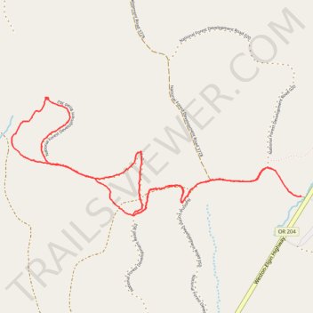
Horseshoe Prairie Ski
- Distance: 6.1 Km
- Elevation gain: 120 m
- Maximum elevation: 1,624 m
- Elevation loss: 111 m
- Minimum elevation: 1,541 m
- Moving time: 1 h 55 m
- Moving speed: 3.2 Km/h
- Maximum speed: 8.7 Km/h
- Total time: 2 h 55 m
- Global speed: 2.1 Km/h
Interactive trail map
Trail profile
- Distance: 6.1 Km
- Elevation gain: 120 m
- Maximum elevation: 1,624 m
- Elevation loss: 111 m
- Minimum elevation: 1,541 m
- Moving time: 1 h 55 m
- Moving speed: 3.2 Km/h
- Maximum speed: 8.7 Km/h
- Total time: 2 h 55 m
- Global speed: 2.1 Km/h
About this trail
Name: Horseshoe Prairie Ski trail, distance, elevation, map, profile, GPS track
Start: National Forest Development Road 050, Union County, Oregon, United States (45.70450 -118.03501)
End: National Forest Development Road 050, Union County, Oregon, United States (45.70611 -118.03736)
Coordinates: 45.70342 -118.05894 45.71027 -118.03501