Mount Wachusett Loop via Bolton Pond Trail, Old Indian and Semuhenna Trail in Wachusett Mountain State Reservation
The Mount Wachusett Loop offers a captivating experience amidst varied terrain. Hikers can enjoy serene forested paths leading to the summit, where panoramic views showcase the distant Boston skyline, particularly stunning during clear weather. The trail combines moderate inclines with sections that reveal interesting geological features like Balance Rock, making it an excellent choice for both casual walkers and seasoned adventurers. #Hiking #Loop #Overlook #Rock #Lake #Forest #Nature
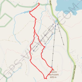
- Distance: 6.4 Km
- Elevation gain: 308 m
- Maximum elevation: 607 m
- Elevation loss: 308 m
- Minimum elevation: 306 m
- Moving time: 2 h 14 m
- Moving speed: 2.8 Km/h
- Maximum speed: 9.2 Km/h
- Total time: 2 h 35 m
- Global speed: 2.5 Km/h
Interactive trail map
Trail profile
- Distance: 6.4 Km
- Elevation gain: 308 m
- Maximum elevation: 607 m
- Elevation loss: 308 m
- Minimum elevation: 306 m
- Moving time: 2 h 14 m
- Moving speed: 2.8 Km/h
- Maximum speed: 9.2 Km/h
- Total time: 2 h 35 m
- Global speed: 2.5 Km/h
About this trail
Name: Mount Wachusett Loop via Bolton Pond Trail, Old Indian and Semuhenna Trail in Wachusett Mountain State Reservation trail, distance, elevation, map, profile, GPS track
Coordinates: 42.48637 -71.89605 42.50799 -71.88708