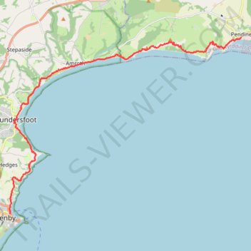
Pembrokeshire Coast National Park Pendine to Tenby
- Distance: 20.2 Km
- Elevation gain: 905 m
- Maximum elevation: 124 m
- Elevation loss: 889 m
- Minimum elevation: 0 m
- Moving time: 5 h 40 m
- Moving speed: 3.6 Km/h
- Maximum speed: 14.9 Km/h
- Total time: 6 h 25 m
- Global speed: 3.1 Km/h
Interactive trail map
Trail profile
- Distance: 20.2 Km
- Elevation gain: 905 m
- Maximum elevation: 124 m
- Elevation loss: 889 m
- Minimum elevation: 0 m
- Moving time: 5 h 40 m
- Moving speed: 3.6 Km/h
- Maximum speed: 14.9 Km/h
- Total time: 6 h 25 m
- Global speed: 3.1 Km/h
About this trail
Name: Pembrokeshire Coast National Park Pendine to Tenby trail, distance, elevation, map, profile, GPS track
End: The Croft, Tenby, Pembrokeshire, Wales, SA70 8AP, United Kingdom (51.67420 -4.70209)
Coordinates: 51.67420 -4.70275 51.74284 -4.55657
Other hiking, mountain biking, running and outdoor activity trails
Click on a trail to view its statistics, map and profile.
Pembrokeshire Coast from Tenby to Trewent Park
United Kingdom > Wales > Pembrokeshire > Tenby
Via North Beach, South Beach, Giltar Point, Valleyfield Top, Proud Giltar, Lydstep Haven Beach, Skrinkle Haven, Priests Nose, Manorbier Beach, East Moor Cliff, West Moor Cliff and Freshwater East.
Distance: 19.9 Km • Elevation gain: 583 m • Maximum elevation: 70 m