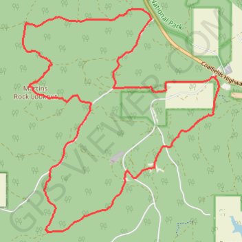
Martins Rock Lookout Loop in the Wellington National Park
Mountain Bike Ride in the Wilderness
- Distance: 22.4 Km
- Elevation gain: 362 m
- Maximum elevation: 282 m
- Elevation loss: 364 m
- Minimum elevation: 177 m
- Moving time: 2 h 3 m
- Moving speed: 10.9 Km/h
- Maximum speed: 36.6 Km/h
- Total time: 2 h 52 m
- Global speed: 7.8 Km/h
Interactive trail map
Trail profile
- Distance: 22.4 Km
- Elevation gain: 362 m
- Maximum elevation: 282 m
- Elevation loss: 364 m
- Minimum elevation: 177 m
- Moving time: 2 h 3 m
- Moving speed: 10.9 Km/h
- Maximum speed: 36.6 Km/h
- Total time: 2 h 52 m
- Global speed: 7.8 Km/h
About this trail
Name: Martins Rock Lookout Loop in the Wellington National Park trail, distance, elevation, map, profile, GPS track
Start: Wellington Dam Road, Worsley, Shire Of Collie, Western Australia, Australia (-33.32153 115.98044)
End: Wellington Dam Road, Worsley, Shire Of Collie, Western Australia, Australia (-33.32194 115.98010)
Coordinates: -33.35439 115.93194 -33.30753 115.98118
Other hiking, mountain biking, running and outdoor activity trails
Click on a trail to view its statistics, map and profile.
Big Tree road area MTB ride
Australia > Western Australia > Worsley
Fantastic Mountain Bike Ride
Distance: 40.4 Km • Elevation gain: 645 m • Maximum elevation: 281 m