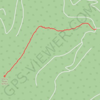
Shorty Peak up
Shorty Peak Trail
- Distance: 4.1 Km
- Elevation gain: 362 m
- Maximum elevation: 1,958 m
- Elevation loss: 9 m
- Minimum elevation: 1,603 m
- Moving time: 1 h 31 m
- Moving speed: 2.7 Km/h
- Maximum speed: 5.9 Km/h
- Total time: 1 h 43 m
- Global speed: 2.4 Km/h
Interactive trail map
Trail profile
- Distance: 4.1 Km
- Elevation gain: 362 m
- Maximum elevation: 1,958 m
- Elevation loss: 9 m
- Minimum elevation: 1,603 m
- Moving time: 1 h 31 m
- Moving speed: 2.7 Km/h
- Maximum speed: 5.9 Km/h
- Total time: 1 h 43 m
- Global speed: 2.4 Km/h
About this trail
Name: Shorty Peak up trail, distance, elevation, map, profile, GPS track
Start: 95 Italian Ridge, Boundary County, Idaho, United States (48.95325 -116.65069)
End: 95 Italian Ridge, Boundary County, Idaho, United States (48.94033 -116.68927)
Coordinates: 48.94017 -116.68927 48.95486 -116.65069