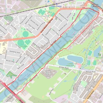
Nepean River - Great River Walk
Interactive trail map
Trail profile
- Distance: 6.6 Km
- Elevation gain: 41 m
- Maximum elevation: 32 m
- Elevation loss: 40 m
- Minimum elevation: 20 m
- Moving time: 1 h 31 m
- Moving speed: 4.3 Km/h
- Maximum speed: 8.1 Km/h
- Total time: 1 h 35 m
- Global speed: 4.2 Km/h
About this trail
Name: Nepean River - Great River Walk trail, distance, elevation, map, profile, GPS track
Coordinates: -33.76534 150.65795 -33.74659 150.68267
Other hiking, mountain biking, running and outdoor activity trails
Click on a trail to view its statistics, map and profile.