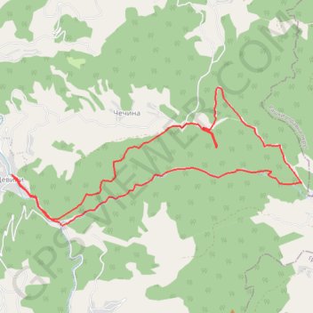
Девићи - Водопади Изубре
- Distance: 10.9 Km
- Elevation gain: 579 m
- Maximum elevation: 1,170 m
- Elevation loss: 579 m
- Minimum elevation: 761 m
- Moving time: 2 h 20 m
- Moving speed: 4.7 Km/h
- Maximum speed: 10.3 Km/h
- Total time: 2 h 20 m
- Global speed: 4.7 Km/h
Interactive trail map
Trail profile
- Distance: 10.9 Km
- Elevation gain: 579 m
- Maximum elevation: 1,170 m
- Elevation loss: 579 m
- Minimum elevation: 761 m
- Moving time: 2 h 20 m
- Moving speed: 4.7 Km/h
- Maximum speed: 10.3 Km/h
- Total time: 2 h 20 m
- Global speed: 4.7 Km/h
About this trail
Name: Девићи - Водопади Изубре trail, distance, elevation, map, profile, GPS track
Coordinates: 43.41699 20.37898 43.43234 20.42306
Other hiking, mountain biking, running and outdoor activity trails
Click on a trail to view its statistics, map and profile.
2022_Yu
Slovenia > Ajdovščina > Žapuže
Distance: 2,457.3 Km • Elevation gain: 32,048 m • Maximum elevation: 1,950 m