Thank you for supporting this site ❤️
Make a donation
Make a donation
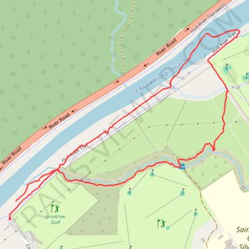
2023-07-12_15-18_Wed
- Distance: 2.7 Km
- Elevation gain: 16 m
- Maximum elevation: 42 m
- Elevation loss: 15 m
- Minimum elevation: 34 m
- Moving time: 37 m 52 s
- Moving speed: 4.3 Km/h
- Maximum speed: 13.9 Km/h
- Total time: 39 m 9 s
- Global speed: 4.1 Km/h
Interactive trail map
Thank you for supporting this site ❤️
Make a donation
Make a donation
Trail profile
- Distance: 2.7 Km
- Elevation gain: 16 m
- Maximum elevation: 42 m
- Elevation loss: 15 m
- Minimum elevation: 34 m
- Moving time: 37 m 52 s
- Moving speed: 4.3 Km/h
- Maximum speed: 13.9 Km/h
- Total time: 39 m 9 s
- Global speed: 4.1 Km/h
Thank you for supporting this site ❤️
Make a donation
Make a donation
About this trail
Name: 2023-07-12_15-18_Wed trail, distance, elevation, map, profile, GPS track
End: Hutt River Trail, Silverstream, Upper Hutt City, Wellington, 5019, New Zealand (-41.14363 175.00146)
Coordinates: -41.14363 175.00139 -41.13731 175.01158
Thank you for supporting this site ❤️
Make a donation
Make a donation