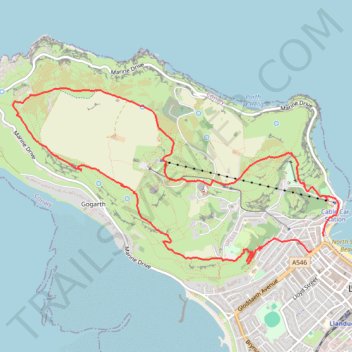
Great Orme Summit and Loop
- Distance: 9.4 Km
- Elevation gain: 357 m
- Maximum elevation: 204 m
- Elevation loss: 355 m
- Minimum elevation: 4 m
- Moving time: 2 h 43 m
- Moving speed: 3.5 Km/h
- Maximum speed: 11.8 Km/h
- Total time: 4 h 50 m
- Global speed: 1.9 Km/h
Interactive trail map
Trail profile
- Distance: 9.4 Km
- Elevation gain: 357 m
- Maximum elevation: 204 m
- Elevation loss: 355 m
- Minimum elevation: 4 m
- Moving time: 2 h 43 m
- Moving speed: 3.5 Km/h
- Maximum speed: 11.8 Km/h
- Total time: 4 h 50 m
- Global speed: 1.9 Km/h
About this trail
Name: Great Orme Summit and Loop trail, distance, elevation, map, profile, GPS track
Start: North Parade, Llandudno, Conwy, Wales, LL30 2LP, United Kingdom (53.32665 -3.83087)
Coordinates: 53.32444 -3.87302 53.33867 -3.82880
Other hiking, mountain biking, running and outdoor activity trails
Click on a trail to view its statistics, map and profile.
Great Orme
United Kingdom > Wales > Conwy > Llandudno
Distance: 5.5 Km • Elevation gain: 233 m • Maximum elevation: 204 m