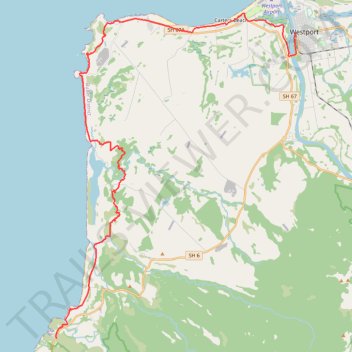
Kawatiri Coastal Trail from Westport to Charleston
- Distance: 41.9 Km
- Elevation gain: 376 m
- Maximum elevation: 53 m
- Elevation loss: 355 m
- Minimum elevation: 0 m
- Moving time: 3 h 10 m
- Moving speed: 13.2 Km/h
- Maximum speed: 32.4 Km/h
- Total time: 3 h 39 m
- Global speed: 11.5 Km/h
Interactive trail map
Trail profile
- Distance: 41.9 Km
- Elevation gain: 376 m
- Maximum elevation: 53 m
- Elevation loss: 355 m
- Minimum elevation: 0 m
- Moving time: 3 h 10 m
- Moving speed: 13.2 Km/h
- Maximum speed: 32.4 Km/h
- Total time: 3 h 39 m
- Global speed: 11.5 Km/h
About this trail
Name: Kawatiri Coastal Trail from Westport to Charleston trail, distance, elevation, map, profile, GPS track
Start: 2, Brougham Street, Buller District, West Coast, 7866, New Zealand (-41.75542 171.59825)
End: 7356, State Highway 6, Charleston, Buller District, West Coast, New Zealand (-41.90629 171.43897)
Coordinates: -41.90629 171.43855 -41.74517 171.59833
Other hiking, mountain biking, running and outdoor activity trails
Click on a trail to view its statistics, map and profile.
Kawatiri Coastal Trail from Charleston to Westport
New Zealand > West Coast > Buller District > Charleston
Distance: 41.9 Km • Elevation gain: 363 m • Maximum elevation: 53 m