ACTIVE LOG
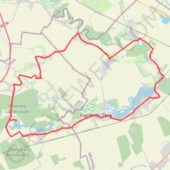
- Distance: 59.3 Km
- Elevation gain: 141 m
- Maximum elevation: 89 m
- Elevation loss: 143 m
- Minimum elevation: 60 m
- Moving time: 4 h 52 m
- Moving speed: 12.2 Km/h
- Maximum speed: 30.3 Km/h
- Total time: 5 h 7 m
- Global speed: 11.6 Km/h
Interactive trail map
Trail profile
- Distance: 59.3 Km
- Elevation gain: 141 m
- Maximum elevation: 89 m
- Elevation loss: 143 m
- Minimum elevation: 60 m
- Moving time: 4 h 52 m
- Moving speed: 12.2 Km/h
- Maximum speed: 30.3 Km/h
- Total time: 5 h 7 m
- Global speed: 11.6 Km/h
About this trail
Name: ACTIVE LOG trail, distance, elevation, map, profile, GPS track
Start: Mănăstirea Căldărușani, DJ101C, Gruiu, Ilfov, 077116, Romania (44.67590 26.26657)
End: DJ101C, Gruiu, Ilfov, 077116, Romania (44.67709 26.25652)
Coordinates: 44.65984 26.25126 44.76753 26.48194