101 Trail and Fire Road
- Distance: 8.4 Km
- Elevation gain: 405 m
- Maximum elevation: 344 m
- Elevation loss: 418 m
- Minimum elevation: 56 m
- Moving time: 2 h 13 m
- Moving speed: 3.8 Km/h
- Maximum speed: 5.7 Km/h
- Total time: 2 h 25 m
- Global speed: 3.5 Km/h
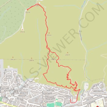
Interactive trail map
Trail profile
- Distance: 8.4 Km
- Elevation gain: 405 m
- Maximum elevation: 344 m
- Elevation loss: 418 m
- Minimum elevation: 56 m
- Moving time: 2 h 13 m
- Moving speed: 3.8 Km/h
- Maximum speed: 5.7 Km/h
- Total time: 2 h 25 m
- Global speed: 3.5 Km/h
About this trail
Name: 101 Trail and Fire Road trail, distance, elevation, map, profile, GPS track
Coordinates: 34.28017 -119.27235 34.30197 -119.25818
Other hiking, mountain biking, running and outdoor activity trails
Click on a trail to view its statistics, map and profile.
Hall Canyon
United States > California > Ventura County > San Buenaventura (Ventura)
From Hall Canyon Road, the route enters Ventura Hills Nature Preserve and follows the quiet canyon corridor between open foothill slopes. It continues along dry washes and coastal scrub typical of Ventura’s protected hillside landscape. The walk reaches the split between West Fork Hall Canyon and East Fork…
Distance: 7.5 Km • Elevation gain: 193 m • Maximum elevation: 131 m
Ventura Hills Nature Preserve Trails 101 and 102 Loop
United States > California > Ventura County > Ventura
Distance: 7.8 Km • Elevation gain: 378 m • Maximum elevation: 260 m
Ride in Ventura Hills preserve
United States > California > Ventura County > San Buenaventura (Ventura)
Distance: 16.7 Km • Elevation gain: 613 m • Maximum elevation: 354 m