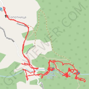
Slapovi Sopotnice kružna staza -Sopotnica waterfalls circle ...
- Distance: 5.9 Km
- Elevation gain: 337 m
- Maximum elevation: 1,114 m
- Elevation loss: 336 m
- Minimum elevation: 940 m
- Moving time: 1 h 50 m
- Moving speed: 3.2 Km/h
- Maximum speed: 45.7 Km/h
- Total time: 3 h 12 m
- Global speed: 1.8 Km/h
Interactive trail map
Trail profile
- Distance: 5.9 Km
- Elevation gain: 337 m
- Maximum elevation: 1,114 m
- Elevation loss: 336 m
- Minimum elevation: 940 m
- Moving time: 1 h 50 m
- Moving speed: 3.2 Km/h
- Maximum speed: 45.7 Km/h
- Total time: 3 h 12 m
- Global speed: 1.8 Km/h
About this trail
Name: Slapovi Sopotnice kružna staza -Sopotnica waterfalls circle ... trail, distance, elevation, map, profile, GPS track
Coordinates: 43.30108 19.73631 43.30638 19.74427
Other hiking, mountain biking, running and outdoor activity trails
Click on a trail to view its statistics, map and profile.
2022_Yu
Slovenia > Ajdovščina > Žapuže
Distance: 2,457.3 Km • Elevation gain: 32,048 m • Maximum elevation: 1,950 m
Mileseva - Sopotnica
Serbia > Central Serbia > Zlatibor Administrative District > Prijepolje Municipality > Kosatica
Distance: 19.4 Km • Elevation gain: 1,514 m • Maximum elevation: 1,338 m
Track
Serbia > Central Serbia > Zlatibor Administrative District > Prijepolje Municipality > Sopotnica
Distance: 63.5 Km • Elevation gain: 2,487 m • Maximum elevation: 1,694 m